


Focos de atención
Lidar Technician, Lidar Surveyor, Geospatial Data Specialist, Remote Sensing Specialist, LiDAR Analyst, Geospatial Mapping Technician, 3D Mapping Specialist, Surveying Technician, Spatial Data Analyst, Mapping and Surveying Specialist, Geospatial Engineer, Lidar Data Analyst, Lidar Systems Engineer, Environmental Mapping Specialist, Geospatial Surveyor
Most of us have heard of radar, which uses radio waves to detect and track objects such as vehicles or weather formations. But not as many people have heard of radar’s cousin technology, lidar!
Lidar (Light Detection and Ranging) is a remote sensing method that relies on light (specifically, laser pulses) instead of radio waves. It’s most commonly used in aircraft to gather information about surface and underwater terrain (e.g., topography and bathymetry).
Though the technology has been around since the 1960s, it came into broader use in the 2000s in areas like forestry, autonomous vehicles, and infrastructure development. Today, lidar (sometimes written as “LiDAR”) is a key technology for self-driving cars, drones, and high-resolution 3D mapping.
With such broad applications, Lidar Mapping Specialists are in demand and will play an important role in advancing geospatial technology and shaping the future of mapping, urban development, and environmental monitoring!
- Contributing to new technologies that improve mapping and spatial analysis.
- Supporting urban planning, archaeology, and environmental conservation efforts.
- Assisting in disaster management by identifying flood-prone areas and mapping damage.
Horario de trabajo
Lidar Mapping Specialists typically work full time in engineering firms, government agencies, transportation departments, or research institutions. Some work is in office environments, but travel and fieldwork in remote locations is common. Schedules vary based on projects.
Tareas típicas
- Research and implement new advancements in lidar technology and remote sensing.
- Plan and conduct data collection using aerial, terrestrial, or mobile laser scanning systems.
- Operate and maintain lidar sensors mounted on drones, aircraft, or ground vehicles.
- Perform quality control checks on equipment before data collection.
- Process raw data to generate high-resolution digital elevation models and point cloud visualizations.
- Apply machine learning and AI algorithms to classify and segment data.
- Analyze and interpret data for applications such as urban planning, forestry management, and infrastructure development.
- Integrate data with GIS (Geographic Information Systems) for mapping and spatial analysis.
- Develop 3D models of terrain, buildings, and vegetation for engineering and environmental projects.
- Assist in flood modeling, coastline monitoring, and climate change impact assessments.
- Collaborate with surveyors, cartographers, engineers, and environmental scientists.
- Create detailed reports and visual representations for clients and stakeholders.
Note, there are several closely related jobs, such as:
Geospatial Analyst – Works with GIS software to interpret lidar data and create maps for urban planning, disaster response, and infrastructure projects.
- Process and analyze spatial data from lidar and satellite imagery.
- Integrate lidar data with GIS platforms for spatial decision-making.
- Assist in environmental impact assessments and resource management.
- Develop thematic maps and 3D visualizations for urban planners and engineers.
Remote Sensing Specialist – Focuses on analyzing aerial and satellite imagery using lidar and multispectral sensors. Works in government agencies, research institutions, and defense organizations.
- Process remote sensing data for climate studies and land-use planning.
- Develop algorithms to detect changes in terrain and vegetation cover.
- Conduct research on emerging remote sensing technologies for mapping applications.
- Support disaster response teams with real-time mapping solutions.
Surveying & Mapping Technician – Assists in field data collection and map creation using lidar and GPS technologies.
- Works in surveying firms, government agencies, and construction companies.
- Use GNSS (Global Navigation Satellite Systems) and lidar scanners to collect geospatial data.
- Assist in creating topographic maps for infrastructure projects.
- Perform on-site calibration of equipment for accurate data capture.
- Work with civil engineers and architects to provide elevation and terrain data.
Funciones adicionales
- Collaborate with software developers to improve lidar data processing tools.
- Train field crews on the use of lidar scanning equipment and data collection techniques.
- Conduct quality assurance and control measures to validate datasets.
- Stay updated on new applications in transportation, archaeology, and defense.
- Present findings and lidar-based analyses at industry conferences and meetings.
Habilidades blandas
- Adaptabilidad
- Analítica
- Atención al detalle
- Colaboración
- Comunicación
- Creatividad
- Decisivo
- Observador
- Organizado
- Paciente
- Resolución de problemas
- Resistente
- Trabajo en equipo
- Gestión del tiempo
Habilidades técnicas
- Depending on their specific roles, Lidar Mapping Specialists may require expertise in:
- Lidar sensor calibration and operation
- Point cloud data processing and classification
- GIS software (ArcGIS, QGIS) and remote sensing applications
- GPS and GNSS data collection methods
- 3D modeling and visualization techniques
- Machine learning applications for feature extraction
- Digital elevation and terrain modeling
- Surveying principles and cartographic design
- Airborne and mobile lidar system integration
- Data fusion techniques for multisensor mapping
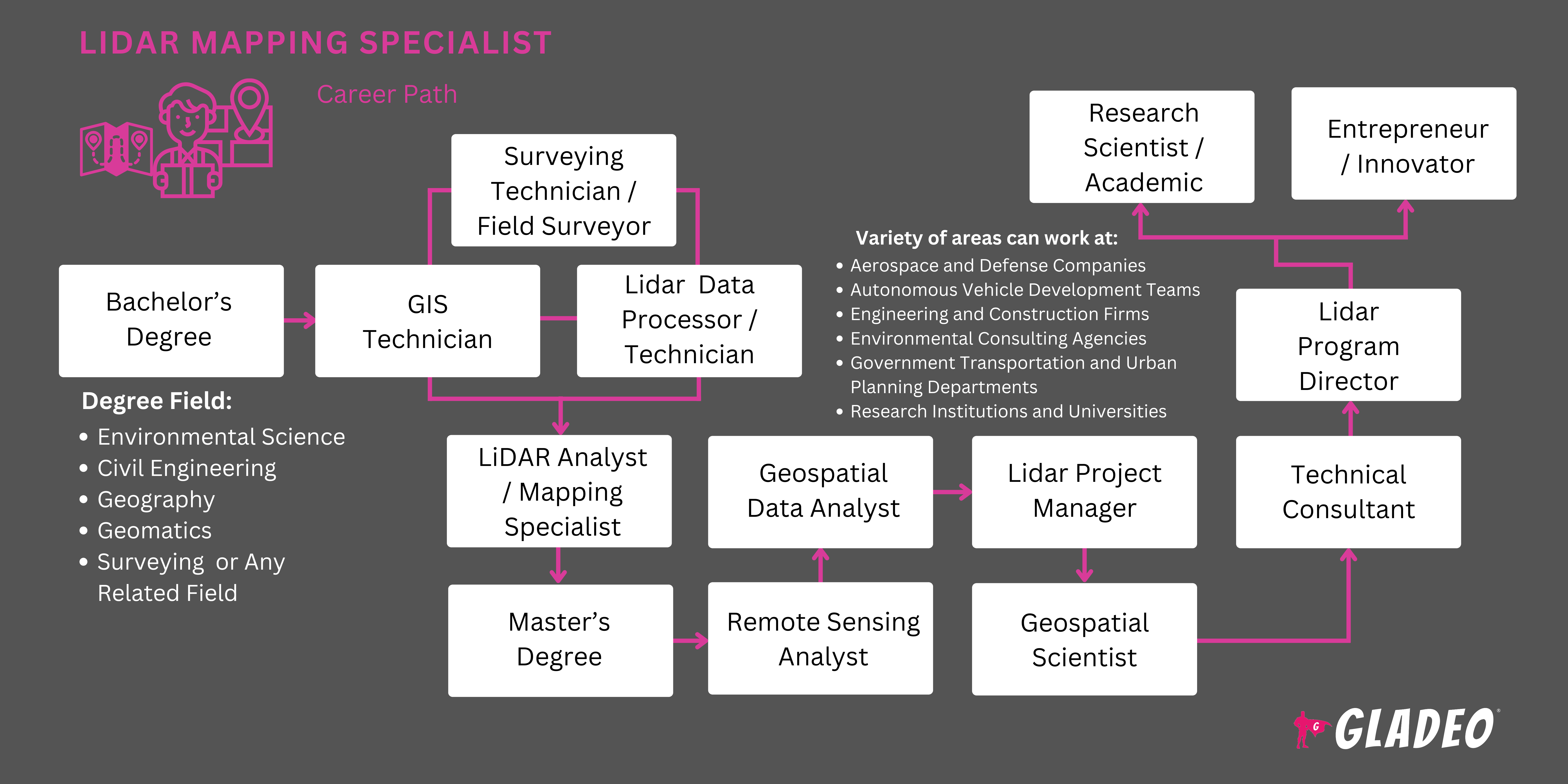
- Aerospace and defense companies
- Autonomous vehicle development teams
- Engineering and construction firms
- Environmental consulting agencies
- Government transportation and urban planning departments
- Research institutions and universities
Lidar Mapping Specialists require precision, patience, and strong problem solving skills. Many of the projects they work on involve large datasets that require extensive processing and quality control, which can be time consuming. Fieldwork can be physically demanding, requiring travel to remote locations and long hours in varying weather conditions. The field is constantly evolving, so professionals must stay updated on advancements in lidar sensor technology, software, and data analysis techniques. While the work can be rewarding, it definitely requires ongoing learning and adaptability!
Lidar technology is expanding across more and more industries, revolutionizing how we gather and analyze spatial data. For example, autonomous vehicle developers rely on lidar sensors for real-time object detection, thus enabling self-driving cars to accurately map their surroundings, detect obstacles, and navigate safely.
The rise of drone-based lidar scanning is also transforming the way topographic data is collected, making it faster, more affordable, and adaptable for urban planning, infrastructure development, and precision agriculture. Even in archaeology, researchers are using lidar-based terrain mapping to uncover ancient ruins hidden beneath dense forest growth!
Meanwhile, climate scientists are harnessing lidar data to monitor environmental changes with unprecedented precision. The technology can be used to track deforestation rates, measure glacier movements, analyze coastal erosion, and assess the impact of rising sea levels on vulnerable regions. It’s even playing a role in disaster management, by helping responders assess flood risks, map wildfire damage, and plan evacuation routes.
One last note – in the lidar community, there is still some disagreement about which is the most suitable letter case to use: lidar or LiDAR? Although the word is an acronym, it is now common enough to be styled as a standard noun. Hence, “lidar” seems to be the most prevalent way of writing it out, but “liDAR,” “LiDAR,” and “LIDAR” are still often seen, too!
Lidar Mapping Specialists may have had an early interest in geography, technology, and problem solving. They might have enjoyed working with maps and 3D model programs, or engaging in STEM clubs or GIS-related projects.
- Lidar Mapping Specialists typically require a bachelor’s in geography, geomatics, environmental science, or civil engineering.
- Advanced roles may require a master’s in remote sensing, GIS, or geospatial science.
- Los cursos universitarios más comunes son:
- Data Processing and Point Cloud Analysis
- Digital Cartography
- Sistemas de Información Geográfica (SIG)
- Machine Learning for Spatial Data
- Remote Sensing and Lidar Applications
- Surveying and Mapping Techniques
Las certificaciones opcionales incluyen:
- GIS Professional (GISP)
- Certified Mapping Scientist – LiDAR (ASPRS)
- FAA Remote Pilot Certification (for drone based lidar mapping)
- Strong GIS, surveying, and remote sensing programs.
- Access to modern lidar research labs and up-to-date mapping technology.
- Hands-on lab and internship opportunities with geospatial companies or government agencies.
- Funding opportunities, including scholarships, grants, and research assistantships.
- Competitive tuition and financial aid options.
Lidar Mapping Specialists can start their search for suitable programs by checking out college program rankings such as:
- Take advanced courses in mathematics, physics, computer science, geography, and environmental science to prepare for rigorous college programs.
- Join STEM clubs, drone-building teams, GIS clubs, or robotics competitions to gain hands-on experience with technology and data analysis.
- Learn about remote sensing and lidar technology through self-study, ad hoc online courses, tutorials, and certification programs.
- Read books, journal articles, research papers, and blogs, explore YouTube channels like Geospatial World and online forums to follow industry trends.
- In college, try to participate in research projects related to GIS, 3D modeling, or remote sensing.
- Attend geospatial technology expos and conferences.
- Volunteer with organizations focused on environmental conservation, land surveying, or urban planning to gain experience.
- Reach out to request informational interviews with lidar professionals. Many are happy to help interested students!
- Keep track of your academic achievements, projects, and internship experiences for your resume and college applications. Develop a portfolio showcasing GIS projects, 3D terrain models, lidar data processing, and mapping experiments.
- Polish your professional portfolio to showcase the latest GIS projects, lidar data processing, 3D terrain models, and mapping analysis you’ve worked on. Keep it organized and easy to understand, while explaining in sufficient detail your role, responsibilities, and the overall impact.
- Network with industry professionals at geospatial technology conferences, remote sensing expos, and surveying association events.
- Apply for internships with mapping firms, environmental consulting agencies, government GIS departments, and aerospace companies.
- Create a LinkedIn profile highlighting your technical skills, coursework, research projects, and relevant certifications.
- Search job portals like Indeed, USAJobs, and the career pages of companies that hire lidar professionals, such as:
- FARO
- Innoviz Technologies
- Leica Geosystems AG
- Luminar Technologies
- Ouster
- Quanergy Systems
- RIEGL Laser Measurement Systems GmbH
- Teledyne Optech
- Trimble Inc.
- Velodyne LiDAR
- Pay close attention to the keywords used in job ads.
- Customize your resume with relevant keywords such as lidar scanning, remote sensing, GIS analysis, 3D mapping, geospatial data processing, and point cloud classification. This should help your application get past automated filtering programs!
- Check out GIS and geospatial resume templates for inspiration, tailoring each application to the specific job.
- Stay informed on industry advancements, such as AI-driven geospatial analytics, drone-based lidar mapping, and advancements in 3D modeling. Be prepared to discuss these trends in interviews.
- You can also prepare for interviews by researching the employer’s mission and current projects, and by doing mock interviews to practice answering questions, such as:
- “How do you process and classify lidar point cloud data?”
- “What software tools do you use for GIS and remote sensing analysis?”
- “Can you explain the differences between airborne, terrestrial, and mobile lidar scanning?”
- Seek recommendation letters or references from professors, research advisors, or internship mentors. Always ask permission before listing someone as a reference.
- Brush up on standard industry terminology and lidar processing workflows.
- Stay updated on emerging trends in geospatial technology, such as real-time lidar applications, autonomous navigation, and AI-enhanced mapping.
- Let your supervisor know you’re interested in career advancement and taking on additional responsibilities. If needed, complete a master’s or Ph.D. in a relevant major such as geomatics, geospatial science, remote sensing, or environmental engineering.
- If a graduate degree isn’t necessary, or if you already have one, knock out some advanced certifications in lidar data processing, GIS analysis, photogrammetry, or geospatial intelligence to enhance your expertise.
- Seek leadership roles and work towards management positions, such as LiDAR Project Manager, GIS Director, or Remote Sensing Lead.
- Earn relevant management certifications such as:
- Certified Mapping Scientist – ASPRS
- Certified Remote Sensing Scientist – ASPRS
- Certified Photogrammetrist – ASPRS
- GIS Professional – GIS Certification Institute
- Project Management Professional – Project Management Institute
- FAA Part 107 Remote Pilot Certification
- Certified Geospatial Intelligence Professional
- Lean Six Sigma
- Attend advanced workshops, webinars, and geospatial technology conferences to expand your industry knowledge and stay ahead of new developments such as AI-enhanced lidar classification, real-time 3D mapping, and autonomous vehicle lidar applications.
- Join professional organizations like the American Society for Photogrammetry and Remote Sensing (ASPRS) or the Urban and Regional Information Systems Association (URISA).
- Collaborate with professionals in AI, machine learning, and drone technology to advance lidar applications in urban planning, environmental conservation, and infrastructure development.
- Publish research or case studies in professional journals like Frontiers.
- Mentor interns and junior mapping specialists.
Páginas web
- Aeva
- American Society for Photogrammetry and Remote Sensing (ASPRS)
- Frontiers in Remote Sensing
- GeoCue
- Geospatial World
- GIM International
- Geo Week
- Laser Institute of America
- Lidar and Optical Communications Institute
- LiDAR News
- LiDAR USA
- MDPI Remote Sensing
- NV5 Geospatial
- Ouster
- Outsight
- UNAVCO
- Urban and Regional Information Systems Association (URISA)
Libros
- Coherent Optical LiDAR: Theory, Modeling and Design Optimization, by Stefano Bottacchi
- Lidar Engineering: Introduction to Basic Principles, by Gary G. Gimmestad and David W. Roberts
- LiDAR Remote Sensing and Applications, by Pinliang Dong and Qi Chen
- LiDAR Technologies and Systems, by Paul McManamon
- The Laser That's Changing the World: The Amazing Stories behind Lidar, from 3D Mapping to Self-Driving Cars, by Todd Neff
Lidar Mapping Specialists play a vital role in collecting and analyzing high-resolution spatial data to support applications in agriculture, environmental management, urban planning, and infrastructure development. But if this career isn’t the right fit for you, there are plenty of related paths to explore!
- Cartógrafo
- Ingeniero de Caminos, Canales y Puertos
- GIS Technician
- Drone Mapping Specialist
- Científico medioambiental
- Forestry Remote Sensing Analyst
- Geospatial Analyst
- Hidrólogo
- Land Surveyor
- LiDAR Data Processor
- Fotogrametrista
- Científico de teledetección
- Surveying Technician
- Planificador de transporte
- Planificador urbano
Newsfeed

Trabajos destacados
Cursos y herramientas en línea